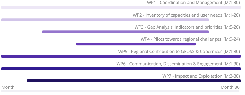
This work package is concerned with the management of the legal, financial and administrative issues of the project in line with established standards. It addresses the smooth coordination between consortium members and across activities, taking into account the multi-regional character of the project. WP1 also includes liaison activities with high-level stakeholders such as the GEO secretariat and the competent units in the European Commission’s DG GROW and DG RTD.
Contact Person: Dr. Haris Kontoes – Project Coordinator & WP1 leader – NOA
The activities carried out by WP2 aim at providing a comprehensive and accurate picture of the existing Earth Observation capacities and skills in North Africa, Middle East and the Balkans. To that end, GEO-CRADLE has launched a stakeholder consultation that includes a dedicated survey and interviews with selected end-users of EO services. The outcomes of these efforts, coupled with dedicated workshops and an analysis of previous relevant projects’ outputs, help to enhance the current knowledge of available space-borne infrastructure, in-situ networks, modelling, computing and human capital capabilities in the region. By doing so, WP2 paves the way for the execution of a thorough gap analysis that is carried out under WP3.
Contact Person: Ms. Elisabetta Fiori – WP2 leader – CIMA
WP3 includes the execution of a thorough gap analysis, highlighting the extent to which existing EO capacities meet the needs of users in the three regions. In this context, the project also elaborates a set of appropriate maturity indicators, a novel proposal by GEO-CRADLE, that allows to capture the level and measure the progress of each country’s involvement in the implementation of GEO and Copernicus. These activities lead to the identification of priorities in response to regional challenges and the definition of an action plan to address them.
Throughout the execution of the tasks of WP3, GEO-CRADLE heavily relies on the strong involvement of several project partners in previous or ongoing projects in the region, as well as on the rich knowledge of EARSC and EURISY on the current state-of-play and future trends in the field of Earth Observation (especially with regards to the development of the EO industry and the uptake or challenges thereof amongst end-users).
Contact person: Mr. Igor Milosavljevic – WP3 leader – INS
Informed by the outputs of WP2 and WP3, this work package includes the execution of four feasibility studies:
- Adaptation to Climate Change (ACC): GEO-CRADLE provides the necessary support and coordination to existing regional infrastructures, to deliver consolidated information and knowledge for long-term strategic planning on adaptation and mitigation to climate change and side effects e.g. (air quality). Thus, GEO-CRADLE aims to integrate the ground-, air- and space-based EO available platforms at the regional level, that in synergy with operational atmospheric and climate modelling capacities paves the ground for holistic monitoring and forecasting of region-specific atmospheric components, ECVs and hazards, in line with the standards and vision of GEOSS and Copernicus for information extraction and service delivery regarding the Climate SBA.
Contact person: Dr. Vasilis Amiridis – T4.1 leader – NOA
- Improved Food Security – Water Extremes Management (IFS): The IFS pilot aims at the systematic integration of soil and mineral data, as well as water and meteorological data. Relying on adequate modelling, and climate projections, the IFS pilot paves the way for establishing practical protocols with regards to collecting and efficiently utilising soil vs plant vs weather and microclimatic information, and for assessing sustainable agricultural development and food security in the region of interest. IFS aims to identify what is feasible, and what is missing from the regional capacities, to support the adaptation, tailoring, and implementation of validated service chains.
Contact person: Dr. George Zalidis – T4.2 leader – IBEC
- Access to Raw Materials (ARM): GEO-CRADLE aims to define the roadmap that facilitates the access and exploitation of mineral resources in extensively under-explored areas, thus creating well sustained businesses, in compliance with widely recognised environmental protection principles. This entails inter alia identifying existing capacities for monitoring of ground deformation during or after mining activities, mapping of waste materials, developing an appropriate protocol for the evaluation of the environmental impact of such activities and enriching the content of the Regional Data Hub with EO-based and in-situ information.
Contact person: Prof. Marek Graniczny – T4.3 leader – IGME
- Access to Energy (SENSE): GEO-CRADLE leads a coordinated effort to support and improve the regional EO infrastructures through the Solar Energy Nowcasting SystEm (SENSE) pilot. The main objective is to coordinate the regional EO capacities and research activities, including those of Copernicus Space and Service Segment initiatives, for the provision of an operational, satellite-driven, real time system for solar energy now-cast. The SENSE pilot draws conclusions on the feasibility of efficiently and sustainably operating relevant EO activities, in terms of existing skills and observational infrastructures, and provides quantitative and qualitative assessments on the required level of coordination and future investment to be carried out towards the implementation of GEO, GEOSS, and Copernicus Energy activities in the region of interest.
Contact person: Dr. Stelios Kazadzis – T4.24leader – PMOD/WRC
Contact person: Dr. George Zalidis – WP4 leader – iBEC
This work package encompasses the items that constitute the concrete and tangible contribution of GEO-CRADLE to the implementation of GEOSS at a regional level, during and beyond the project’s lifetime. This entails: establishing the GEO-CRADLE network, setting up and operating the Regional Data Hub and elaborating a roadmap for the future implementation of GEOSS and Copernicus in the region.
Contact person: Dr. Vangelis Gerasopoulos – WP5 leader – NOA
The objective of this work package is to ensure that the impact of the GEO-CRADLE project is maximised through an effective campaign of communication, dissemination and engagement activities. This is based on a well-defined strategy, a toolbox of communication and outreach materials and on the exploitation of the multiplier effect of the various networks represented in the consortium.
Contact person: Ms. Eleni Christia – WP6 leader – NOA
In this work package, the objective is on one hand to establish a reference system for monitoring and assessing the impact of the various activities during and beyond the duration of the project; and on the other to define and implement a sustainability scheme guaranteeing the long-term exploitation of the project results and the sustainability of the expected impacts across the various activities.
Contact person: Mr. Eleftherios Mamais – WP7 leader – NOA