ESA: "Space for our Climate" - African Land Cover, 3/10/2017
3 October 2017
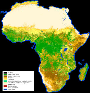
From the barren Sahara to lush jungles, the first high-resolution map classifying land cover types on the entire African continent has been released. The map was created using a year’s worth of data from the Sentinel-2A satellite.
At a resolution of 20 m per pixel, you can now explore African’s diverse landscapes from grasslands to croplands, water bodies to deserts.
Recent News