EU project GEO-CRADLE successfully launched with the aim to establish a network of stakeholders and a Data Hub for Earth Observation (EO) in North Africa, Middle East and the Balkans
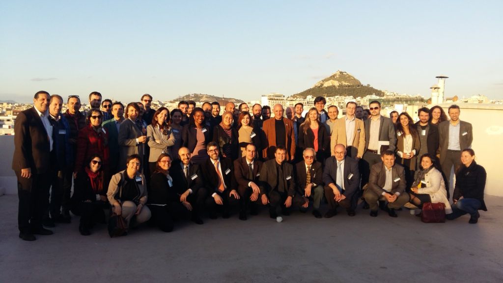
Athens, Greece 18-19 February, 2016 – GEO-CRADLE, a new project coordinated by the National Observatory of Athens (NOA) and funded under the European Union’s Horizon 2020 Programme was successfully kicked-off against the backdrop of the city’s historical centre.
The two-day meeting, serving both as the official kick-off of the project and as a first regional workshop, took place at the emblematic Ionic Centre. The event was attended by 85 participants from North Africa, Middle East and the Balkans, including representatives of the GEO-CRADLE consortium members, officers from the European Commission and the GEO secretariat and other regional stakeholders.
The GEO-CRADLE consortium brings together highly-esteemed research institutes, public authorities, specialised SMEs and leading international associations, combining a wide range of expertise in monitoring our planet’s environment via an ensemble of diverse EO technologies (e.g. remote sensing, in-situ, synergies with state-of-the-art models) in the areas of Climate Change, Raw Materials, Food Security, and Energy. As the project coordinator Dr Haris Kontoes, research director of the National Observatory of Athens, highlighted in his introductory speech, these partners join forces with the overarching objective of establishing a multi-regional coordination network that will:
- Support the effective integration of existing EO capacities (space/air-borne/in-situ monitoring networks, modelling and data exploitation skills, and past project experience),
- Provide the interface for the engagement of the complete ecosystem of EO stakeholders (scientists, service/data providers, end-users, governmental organisations, and decision makers),
- Promote, through dedicated feasibility studies, the concrete uptake of EO services and data in response to regional needs across four thematic priorities: adaptation to climate change, improved food security, access to raw materials and energy
- Contribute to the improved implementation of and participation in GEO, GEOSS, and Copernicus in the region.
In this context, GEO-CRADLE will set out to establish a regional Data Hub serving as a “one-stop-shop” that facilitates access to and sharing of geospatial data and information collected from satellites and ground-based networks. In addition, the GEO-CRADLE Portal will act as an interface between scientists and diverse data providers, providing a single point for the stakeholders to identify existing data, skills, gaps and complementarities, necessary for the development of synergies and market opportunities across the entire value chain and in relation to regional priorities. By doing so, GEO-CRADLE aspires to catalyse further promotion and tailoring of Copernicus data and services within the region, while leveraging the integration of North African, Middle East and Balkan EO capacities in the Global Earth Observation System of Systems (GEOSS).
As underlined in the opening speech by Ms Gaelle Le Bouler, the European Commission Project Officer (representing the Executive Agency for Small and Medium-sized enterprises – EASME), “the integration of users in the project is crucial, for the project to respond to real market needs”. To that end, the project activities have commenced with the construction of a comprehensive mapping of regional EO capacities in the four thematic areas (climate change, food security, access to raw materials and energy) and a thorough analysis of corresponding end-user needs.
In that context, GEO-CRADLE invites all regional stakeholders to be involved in the project’s activities starting with the surveys that will be launched at the beginning of April. These surveys will support the identification of regional gaps and challenges and the elaboration of a comprehensive overview of EO maturity in the region. The surveys will be supported by conducting interviews, and filling up specific questionnaires which will become soon available (in April 2016) at the web site of the project. Coupled with four feasibility studies in the respective thematic areas, these activities will facilitate the uptake of EO data and services in the region, in support of better market opportunities for EO companies and SMEs and informed decision-making for end-users. Organisations from North Africa, Middle East, and Balkans, either from the public or private domain, belonging to the End User and/or Service/Data provider communities will benefit from filling in the survey questionnaire, as it allows them expressing their information needs, inform the wider audience about their skills and capacities, and become part of the regional stakeholders network which will seeks to implement GEO, GEOSS, and Copernicus in the three regions of the project.
GEO-CRADLE Coordination and Support Action
H2020 Framework Program-Climate action, environment, resource efficiency and raw materials
ACTIVITY:
Developing Comprehensive and Sustained Global Environmental Observation and Information Systems
CALL IDENTIFIER:
H2020 SC5-18b-2015 Integrating North African, Middle East and Balkan Earth Observation capacities in GEOSS
Project GA number: 690133
Contact:
Overall Project Coordinator:
NATIONAL OBSERVATORY OF ATHENS, Dr Haris KONTOES (kontoes@noa.gr)
Geo-Cradle Press Releases:
Recent News